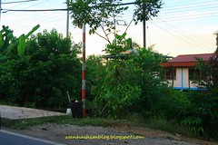
If you travel toward Kuching along the Federal Road just several kilometres before Serian's bridge, you will notice several flood level markers located besides the road.
The markers reminded me that the stretched of road is prone to flooding. Whenever the stretch of road is flooded, the main access from major cities in Sarawak to Kuching will be cut off.
During flood, the water level is very high since the existing elevation of the road is already quite high relative to the water level of the nearby river.
It should be a high priority for the related authority to upgrade the stretch of road to prevent future flood and to provide continuous access throughout the year to Kuching.
No comments:
Post a Comment